Monday, July 30, 2012

The Littledean cherubs


The other day I stopped off at Littledean churchyard on the way back from somewhere else. My reason for stopping was quite simply that I was stuck behind a double-decker bus trundling along at 20 miles an hour and it was driving me bonkers, and as the church looked old and curious I thought it was worth pausing there rather than grinding my gearbox any further.

Littledean is an interesting place on many levels. It's an ancient crossing-over point where many old tracks meet. It sits on the cusp of the Forest of Dean but it overlooks the lush valley where the River Severn does a lurching loop in the shape (so some say) of a Celtic torc. Among its many curiosities are an 18th century prison housing, amongst other things, the world's largest collection of Quadrophenia memorabilia, and which was also the site of Gloucestershire's last witchcraft trial (as recently as 1906). The beautiful old house Littledean Hall traces its roots into Saxon and Celtic times and has enough hauntings to bliss out the most demanding paranormal investigator, and, of particular interest to my Sulis Manoeuvrings, it has in its grounds the remains of a Romano-Celtic temple sited over a spring and thought to have been dedicated to Sabrina, the goddess of the River Severn. So a return visit is in order, but in the mean time I want to focus on Littledean churchyard and its chubby-cheeked cherubs.


Littledean church is a funny looking thing, so you can see why it appealed to me. It originally had a spire but it fell down in a gale in 1894 and has been replaced by a little squat wooden structure on top of the tower. The church is essentially 14th century (parts of it are older) but has had a few alterations, and is dedicated to the Saxon saint St Ethelbert (that would most likely be the canonised King Æthelberht II of East Anglia, who was around in the 8th century AD).

As a lifelong lover of old gravestones, however, it was the abundance of quirky cherub-topped monuments which caught my attention here. The best ones mostly date from the 18th century and some may be the work of one local stonemason or a small group of different masons with similar tastes. They belong to a distinctive style of Forest of Dean headstone but I can only really let them speak for themselves.

His 'n' hers matching gravestones in varying states of dilapidation. These belong to Thomas and Frances Hobbs and date from the 1750s.

A lovely job from 1744 in memory of James Overd and his daughter Sarah. I like the way the relic of old ivy twig makes it look like the cherub on the right is sucking a straw.

All right, there's no cherub on this one (grave of E. P. 1759) but it has lots of other interesting details. A winged hourglass symbolising the flight of time is encompassed by an ourobouros symbolising eternity, flanked on either side by deathly symbols of crossed bones and a pick and shovel. Underneath is the cheery slogan "When God cuts short the thread of life/Then fatal Death Parts man & Wife"

An earlier headstone dated 1686, and it's interesting to see the difference in design, both in terms of the stylised flowers and fruit and the cherubic hairdo. The inscription is damaged but commemorates John Adams and his daughter (her name is lost).

Another older one, by the look of it, with a decidedly ugly cherub.

Not as ugly as this one though. Yipes! Grave of thomus, son of James and Mary Morgun [sic], dated 1700.

And over time the carving becomes more realistic. This stone for Sarah Horner who died in 1795 aged 59 has a cherub which gives the impression of being a likeness of a real person, with lovely leafy drapery issuing from the centres of two flowers at the top and passing through a pair of rings.

Succulent cherubs and blossoms on a tomb which commemorates "John Reynolds one of ye Keepers of ye Forest of Dean who died May 1740 Aged 47 Yrs" and Ann, his wife, who died in 1756.

Moving forward to 1822, and on this headstone for John Grindell of Greenway we have cherubs straight out of a late 1960s rock band.

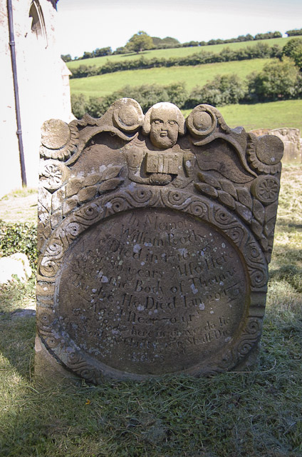
I'm rather fond of this one with its little fat-faced cherub holding a book in its spindly arms. It's in a different style from anything else in the churchyard and marks the grave of William Rock (died 1716) and Thomas Bugbe (died 1739). It's not clear what the connection is between them or why they were buried together.

Beyond this, Littledean is a closed door which invites your curiosity but doesn't yield up its secrets lightly. Perhaps appropriately, I've never seen so many walled up doorways in one church - I counted at least three!

Monday, June 11, 2012

Cleeve Knolls


To the Whispering Beech of Cleeve Hill

Soft shake
sculpts the surge
                          as strung out twists,
the permanent forms of the blast
proud in centrifugal spin
                                        cross the five ways

Gold stater slipped in the Malverns purse
Their bulbous jointed horse
                                            clears the ditch
Triple whip-tailed
                             copper, iron, gold

Cirrus makes
                      slate-sliver
on the beacons, blue extrusion
as sky and valley
spreads its table for the day's crumbs

Lamb lands on a ewe's flat back
solicits no reaction
circular jaw
masticates the springing green

Watcher of the old bowed track
silent pinion on
                          serene scars
the cup and ring grained in the turf

As the wind sings down your
fluting ridge and furrow
you tingle with every voice
that ever cut this breeze

Whispering beacon, destiny cross
copper-crowned queen of knolls


Wednesday, May 30, 2012

A walk in the sacred landscape: Uley

Hetty Pegler's Tump

It has taken over five thousand years to work the spiritual loom over the land between Uley and Nympsfield, two villages up on the Cotswold scarp between Stroud and Dursley. The area is overflowing with ancient monuments, you can barely move without stubbing your toe on a long barrow. But it seems to me that, with so many meaningful relics in such close proximity, the whole of this area must be a sacred place in its own right. Indeed the name Nympsfield is thought to mean "field near the holy place". So as well as taking in some of the obvious tourist spots, it seems to me it's worth sauntering around and in between them to see what might be here that isn't on the map.

My visit to this site starts with my meeting Western Mysteries author Gordon Strong at Hetty Pegler's Tump, in my capacity as publisher of his forthcoming book. The insides of Neolithic burial chambers are not the conventional place to have publishers' business meetings, but that's the advantage of co-running your own press – you can be as weird as you like. I stop off en route for a flying visit to Nympsfield Long Barrow and its Bronze Age neighbour the "Soldier's Grave", a round barrow hidden in the adjacent woods. Ever the rabid snapper, I have to lie on the ground to get the best camera angle on the Nympsfield stones, but fortunately Gordon knows what I'm like and isn't bothered that I turn up looking dishevelled and smelling of fox wee. Hetty Pegler is welcoming ... she smells a bit damp and wee-like herself.


Inside the 5,000-year-old tump (above) there is plenty of space to sit comfortably and chat about the powers and origins of barrows, the electric torch redundant as the sun pelts against the east-facing tunnel entrance and illuminates the passageway just enough to create a pleasant twilight. I sit with my back to a pitch dark side chamber and Gordon asks me my views on the purpose of barrows, so I talk about ancestors and the disarticulated burials, how the barrow people moved and mixed the bones. Like most Cotswold barrows, Hetty Pegler's Tump contained at least 20 skeletons, all jumbled. I'm just waffling on about how lovely and peaceful barrows are, and that even though they are burial chambers they never feel like graves, more of a comforting, nurturing sanctuary where you hang out with the ancestors and never feel frightened. At that moment there is a strange scratching noise in the darkness behind me. "What the fuck is that?" I strain to identify it. Maybe it's a rodent burrowing in the earth on top of the barrow? No, it's definitely something moving about in the chamber behind me. A gnawing, scratching, fluttering noise that gets more intense the longer I sit there. Bugger. Am I going to get a rat running across my leg or a bat whistling past my head? Fortunately neither transpires. I still don't know what it was. I gave the chamber a once-over with the torch on the way out and couldn't see anything.

Looking outwards

Hetty Pegler's is one of the most atmospheric long barrows I've ever visited, and here's a curious thing: this tump has been ravaged and savaged multiple times and what "survives" today is largely a reconstruction, and yet it remains imbued with a tingling sense of potency. Whereas poor old Nympsfield Long Barrow, its mound scalped and its stone chambers standing open to the sky, has almost no atmosphere left at all that I can discern. Putting aside the obvious psychological factor that a dark passageway underground is always going to be more evocative than an open ruin, I sense that the power of a long barrow is connected to enclosure, darkness at its core. When light floods into its hollows and the sun warms the stones, ephemeral ancestral threads dissolve away. The opened barrow is disengaged, its dynamo unhitched.

 Nympsfield long barrow: nice orthostats, shame about the vibes

An hour later Gordon has gone on his way and I saunter on up to Uley Bury, a fairly enormous Iron Age hillfort perched above the village. The middle bit is fenced off and accessible only to cows, but you can walk around the perimeter, between the ramparts. It's more than a mile all round, and the sun is starting to blaze, but emboldened by a tasty half of Pig's Ear ale from the local Uley Brewery, I set off. Within minutes I'm down on my hands and knees inspecting the wild blossoms. What caught my eye was this rather beautiful vetch blossom. Vetch is very common; I suppose that's why it's called Common Vetch. But I was struck by the intense and velvety purple of this particular patch growing on the ramparts – far more vivid in colour than the stuff I usually see.

Vetch, in beautiful magenta-purple, alongside some speedwell and a plantain "sparkler". To me, no domestic flower garden is as beautiful as this.

Uley Bury holds a memory of the Dobunni people; their golden horse emblems have turned up here on the odd coin find. Some parts of the fort are more atmospheric than others, and it seems to be focused in hotspots. On more than one occasion I am drawn towards a tree on the ramparts which seems to be blazing with inner life, only to find when I approach it that the ground yields beneath the grass and I'm standing over a not-quite-breaking-the-surface spring. The most striking of these trees is a mature elder close to the southern gateway, which stands as a green beacon, flaming on the inner levels. A stream of umbelliferous blossoms courses by at the root.


The outer plane view is pretty stunning too, especially to the south and west. A smoothly exquisite tump, Downham Hill, rises from the perfect greenness of fields. It's naturally formed, a natural outsider, a bubble that spurted from the contiguous heave of the Cotswolds, but with its glorious contours and soft sculpted shape and the little flutter of trees on the top, it looks like a giant long barrow.

Downham Hill, as seen from Uley Bury

During my walk around Uley Bury, I spot a translucent rainbow on the ground. Digging it out I find a small shard of glass, old bottle-glass weathered smooth, aqua-green with iridescent curves which the sun brings out in all colours as I turn it different ways in the light. I get a sense I may need it for something so I slip it in my pocket.

Scorched, dehydrated and knackered, I get back to the car to find that the lock has seized up and I have to climb in the passenger side. (Plus ça change – I once had a Ford Capri whose driver's door fell off completely, so let's be grateful for small mercies.) By this time I feel like calling it a day, but there is another sacred landscape at Uley which needs homage paid to it. This is one you won't find on the maps; it is hidden. Or to be more precise, it is so open you can't pin it down to any focused location. The whole hillside is implicated.

Uley Bury

The surface story goes like this. Between Uley Bury and Hetty Pegler's Tump is an east-facing slope called West Hill. A Romano-Celtic Temple of Mercury once stood on the top of this slope, the remains of which came to light during 1970s drainage pipe manoeuvres, close to the road and within view of Hetty Pegler. A subsequent excavation recovered its decapitated statue, now in the British Museum. It also turned up a substantial scatter of cursing tablets. These tablets, similar to the ones famously found in the Temple of Sulis in Bath, solicit the help of the Roman god in kicking the arse, literally or metaphorically, of an assortment of petty thieves and snotty neighbours. "I ask you that you drive them to the greatest death," one bloke petitions as a fate for three named individuals "who have brought evil harm on my beast". A chap called Biccus, a victim of theft, requests that the thief "may not urinate nor defecate nor speak nor sleep nor stay awake nor [have] well-being or health, unless he bring (the stolen item) in the temple of Mercury". The indictment was scratched into the surface of a small sheet of flattened lead, then folded up and tossed into a sacred well; the temple at Uley is thought to have had a pool in the middle for this purpose. Nearly all the curses here relate to thefts: of livestock, clothing, or household items, and in an age when there was no police force or criminal justice system, a good old zap from the Punitive Ray was probably the most realistic chance of getting redress.

I'm not a fan of cursing (despite my involvement in quasi-witchery I don't believe there is ever, under any circumstances, any justification for it) and neither am I a huge fan of the Romans, whose culture and remains give me no great spiritual connection. But what draws me to this site is that its sanctity goes so far back in time, the ranting Romans are actually little more than a flash of noonday sun on this sacred hillside. There was a temple here thousands of years before Mercury ever shook his curly locks and wiggly staff on these shores.

Given that there is now no visible trace of the temple on West Hill, it remains for the imagination to visualise the scale of it. There was a large complex here by the first century AD – lots of buildings, including accommodation, shops and bogs. But the archaeologists found traces of a Neolithic enclosure around the temple site, dating the shrine back a further two thousand years. A previously unknown round barrow was discovered (ploughed flat and now invisible) by the roadside. They also did a magnetometer survey over an area some way beyond the excavation site and found extensive and varied soil disturbance, too jumbled to interpret, which suggested an active presence in this place over a wide area and long timescale (Woodward & Leach, 1993).

My purpose today is not to find the physical location of the temple, but to attune to the landscape that held it. I want to know why the Neolithic people, the barrow-builders who made Hetty Pegler's Tump, chose this place as their shrine. I want to know what native deity or genius loci presided over this place and what traces it has scratched through the ethers.

The starting point for this is selected: a footpath down through Toney Wood. I just want to follow my instincts and not plan out this walk. Climbing by necessity out of the wrong side of the car, I take a left fork through the woods and soon find myself squelching through the mud of not-quite-evident springs.


It's really hard to describe the ambience of Toney Wood. It's Otherworldly to the point of feeling unreal – almost hallucinatory in its strangeness. It's not at all like the usual Gloucestershire faery woods, and is altogether more awesome – in the true sense of inspiring awe. Mildly unsettling too, but more because of its raw power than any focus of malevolence. It's a very old, mature wood and the trees are tall, which wipes out a lot of the light. The sun's orb dazzles the upper canopies but the pathway is dim. All around there are sounds of movement: branches sway, twigs crack. I'm most definitely not alone here.

This wood has a feel of being simultaneously immutable and in a constant state of change. The pathway cuts alongside a steep bank whose earth face is draped with old ivy and yet freshly crumbling away its layers, ever revealing. Looking at the fresh tumbles of red earth and pale stone I have a sense that if I so much as touch this surface it will fall away and expose the bones of the long dead, or other traces of old things hidden inside. I try to align my senses with the underlying layers, the resonance of a native spirit of place.

The logical assumption is that the pre-Roman deity must have had similar attributes to Mercury, since that's who replaced him (or her). But not necessarily. Stephen Yeates in his book A Dreaming for the Witches notes that the temple on West Hill was aligned so that the rising sun would stream through the entrance and illuminate the statue of Mercury on certain days in late April and early May, almost corresponding to the feast of Mercury on May 15th. From this he suggests that Mercury was chosen as the replacement god not because he had similar attributes to the local deity, but because he occupied an equivalent feast day (which may have been on or near Beltane). This rings fairly true to me, seeing as how Christianity subsequently superimposed itself on the native faith by subsuming its feast-days. I also read somewhere that the pre-Roman Uley shrine had been connected with the stag-god Cernunnos. Can I detect any feel of Cernunnos-vibes here, I wonder, as I descend through the sloping woods? At that moment there is a loud crackle of breaking twigs to my left and a swish of movement, and I turn to see a large deer pelting away through the trees.

The path presents me with choices. I try to follow intuitions, and one time when I take a path based on rational sense rather than instinct, a voice in my head says "wrong way! go back!" Following this imposed course I venture into the adjacent copse, Ring Wood. Heading towards sunlight and the green of a field glimpsed through the trees, I find the place I have been meant to discover. A thick mossy drystone wall holds back the forest, and on its other side is a low drop into a semicircular enclosure. From this circle of tree-ringed ground a stream emerges and chuckles away down the hillside. An old iron-barred stile, almost hidden, allows entry.

The alder tree above the spring. One well-head rises under the roots of this tree, the other can be seen emerging from the ground top right.

This is indeed a sacred spot. Admittedly it doesn't look that exciting, and its main use in these secular times is for cattle, as a drinking hole and occasional toilet. The enclosure is a squelching mire of their footprints, in deceptively deep mud. Tree roots weave the surface, which is spread with stone tumble, flat limestone bricks. A few bits of plastic litter and an old car tyre add a touch of modern decor. But on inner levels we have something special here. It is a double spring, a two-headed source. These are polarised, active and passive. One spring ripples straight out of the open ground, its current pulsing against the palm of my hand. The other emerges from a crease in the ground under the roots of an alder tree, and although it produces water at a similar rate, appears placid and completely motionless. In fact it took me a while to realise it was a spring because at its source it appears not to be flowing at all. A few yards from the twin springs the waters blend together and make a little stream, polarised unity.

Was this double-spring ever revered as a sacred place? Who knows. It's quite some distance from the temple complex, but then this whole area was in a sense a part of the temple, and there's no knowing which of the many springs on this hillside, if any, were singled out for special attention. I can't even be sure whether this double-headed flow existed in ancient time: some springs dry up over time, while others newly reveal themselves. But in recognition of this being a special place now, solitary, penannular and cowtrodden, I offer my piece of rainbow-sheened glass among the stones of its bed.

The "active" spring emerges from the earth.

If the atmosphere in Toney Wood was a little bit unsettling, I have to say there is a similar tension about this place. The polar spring itself is naturally buoyant, but there's something overlaid on the top, a thinly netted veil laid on the field. A little of its exuberance is stifled by this dusky web. Perhaps this negative tension is only to be expected in a place where people have pinned their curses, even if this isn't the cursing well itself. The Romans went in for cursing in a big way, but whether the practice of cursing has an older lineage in Uley, who knows. As far as I know there's no evidence that earlier peoples practised it, which is not to say that they didn't. It is, of course, perfectly possible that they did so without the relative permanence of inscribed lead. Perhaps a veneer of negativity on this place is inevitable.

I move on, down the slope into the sunlight, following the course of the young stream. The Ordnance Survey shows a footpath here, but there is none: a little used public right of way which leaves no track. The terrain is difficult as the cows' feet have left treacherous hollows under the grass; I have to reroute myself a little way into the field to avoid a twisted ankle.

The cattle are clustering. They move en masse to a scrape of bare earth in an adjacent field – another spring. I decide not to explore this one as it's on private property. But the terrain of many wells is clear.

And then I hear the sound of rapid sploshing water close by. Another circle of earth, hollowed and muddied and shaded by a ring of trees, but while the double-spring was presided over by alder, this one has a guardian of thorn. White may-blossom nods in the shade. Energies are feminine, and waters splurge. I can't get close to the spring itself but I can see it. Waters pouring from a gap, not in the flatness of the earth like the previous springs, but in a small vertical bank, straight from the tangled rootball of a hawthorn. The stream from the double-spring meanders in a reverent circle around it before meeting with its waters lower down. If there is a sacred well in this field, then this is surely it. Its powers flow forth, a gushing spark undiminished by nettles, barbed wire and the smell of biodegrading dung.


A small bridge takes me over the stream and into a sunny field, where my path is immediately sliced off by an electric fence right across the footpath. A short tube of hosepipe hangs on the wire, presumably to discourage hapless ramblers from blundering into the fence without seeing it. And perhaps to provide a zap-free passing place. I contemplate this obstacle. Under or over? Not ideal either way. On balance I decide to go for the undignified shimmy, and find myself for the second time today slithering along the grass on my front.

From here it's not easy. The electric fence scores an artificial ring within the meadow, and I can't get back to the woods. The only obvious footpath leads to the farm in the valley, in completely the wrong direction. I choose to forge my own path around the field edges, back up the hill towards the wood, hoping for an opening when I get there. Knee high grass and buttercups. English meadow magic. Marred by a distant warning as a tractor two fields away begins to creep towards me. Having strayed from the authorised track I now fear a bollocking.


Hogging the headlands I struggle up the hill. Grass becomes waist-high, buzzing with pollen, surging through umbelliferous blossoms and the squish of underfoot springs. That this hillside is a whorl of springs I already knew; the satellite image on Google Streetview shows the hidden watercourses as cropmarks, a tangle of meandering serpent outlines scotched in the grass. I reach the edge of the wood, but there is no way in. Threefold barbed wire lines the boundary. The electric fence, the farmer's curse, strings through the tall grasses.

And then a merciful stile appears, and I'm into the cool of the woods. Too knackered now to get back up the slope. Light-headed and struggling to breathe, but the strangeness of Toney Wood offers little respite. I sense the antiquity of the track, hauling me into its time loop. So I sit down on its bank to catch my breath, and watch the shining ones dance in their hall among the trees. Their floor level is below the ground of the present forest. I'm an outside observer acknowledging their music and colour. And then I move on, because if I rest here too long I probably won't be able to get up again.

I am, as it happens, just a few yards from the Romano-Celtic temple, invisible though it is beneath the ploughsoil. But the temple site is just a hub. Out from its core spins the weaving of a sacred landscape, where every twig carries the tremors of its weft.


Sources:
Bord, Janet, Cursing not Curing: The Darker Side of Holy Wells (article available online)
Woodward, Ann, and Leach, Peter, The Uley Shrines: Excavation of a ritual complex on West Hill, Uley, Gloucestershire 1977-9 (English Heritage, 1993).
Yeates, Stephen, A Dreaming for the Witches: A Recreation of the Dobunni Primal Myth (Oxbow, 2009).
Several pages about Uley on Curse Tablets from Roman Britain website.

Wednesday, May 23, 2012

Of snorkelling imps

A trippy skip through the medieval English imagination, as expressed in carvings on old churches and elsewhere, taking in the fretfully bizarre and bordering on the loony. This is the first of an occasional series.

Beckford, Worcestershire

How I love this alien creature, committed to stone in the 12th century and still defying interpretation. In body it appears to be a centaur, with a sequence of deep-carved dots all down its side and onto its flank. But what the heck are those snail-like appendages at the back of its head? Antennae picking up the vibrations of the cosmos? Or just a very weird hairdo? It has an enormous, bulbous eye, carved in monstrous relief, its little mouth open in surprise. And it appears to be wearing a chevron T-shirt. What's also intriguing, but not visible in this shot because the carving goes round the pillar and it's not really possible to see the whole thing all at once, is that it bears a spear. Not that it's carrying one exactly, but there is a tall, pointed, upright spear levitating just beyond its outstretched hand.

This is just one of many 12th century carvings in Beckford parish church, and they show a wondrous diversity. I don't know whether it indicates that the Norman-era stonemasons had a sense of humour, or were consolidating now forgotten myths, folktales and visions, or whether there were a lot of groovy mushrooms growing in the vicinity at the time. Part of the bargain in enjoying this legacy of imagination is that we have to wonder, and not excessively analyse.


Beckford, Worcestershire

What's going on here then? This is the same chancel arch that hosts our little alien friend above, but on the opposite side. The pillars have these carved capitals bearing a chevron design – the Normans liked their chevrons – but while the capital on the right bears a spiral design with a certain Celtic/Saxon flavour, the larger one on the left has an upside-down and folded-up snake in it, bearing a rather miffed facial expression (as well he might).


Beckford, Worcestershire

And here's the centrepiece of Beckford church – the tympanum above the main door, featuring a horned ass, a bird perched on a cross opposite a levitating disc, and a rather stiff-legged cow type thing with five horns. Well, why not?


Tewkesbury Abbey, Gloucestershire

This is the carving I call the snorkelling imp, but God only knows what it is. Tewkesbury Abbey is famous for its carved roof bosses, but this is one of its lesser known carvings and is easily missed. It actually sits outdoors overlooking the site of a destroyed chapel on the north side. I don't think it belongs in its current position and has probably been stuffed into this niche for decoration. It has a flat top, and its fluted base looks like it may once have been the base of a pillar or something of that ilk.


Hawkwood College, near Stroud, Glos

OK, so this screaming corbel isn't medieval or on a church, but it clearly echoes the style of medieval church carvings. It's perched high on the gables of Hawkwood College, a magnificent adult education establishment between Painswick and Stroud which started life as a Victorian-Gothic manor house and is an incredibly atmospheric place to spend a weekend. The house was built in the 1840s.


Stanton Drew, Somerset

The church at Stanton Drew is quite an interesting place despite being eclipsed by its megalithic neighbours – it sits slap bang on an alignment between the Cove standing stones and the stone circles. Among its features are these lovely gargoyles. These examples look too fresh to be "originals" from the church's foundation, but they do echo the style of some very weathered medieval gargoyles on other parts of the church.


Stanton Drew, Somerset


Stanton Drew, Somerset


Stanton Drew, Somerset

On the very top of the tower, this is one of the original medieval gargoyles at Stanton Drew. A very Celtic-looking stylised face with bulbous eyes, and with long hands holding its mouth open.


Overbury, Worcestershire

This final batch of weirdness can be found on St Faith's church in Overbury, a village on the slopes of Bredon Hill and just up the road from Beckford. This glorious old church is very well worth a visit, the inside being full of 12th century carvings. The tower is 15th century, and has four "guardians" at the corners, all different. Their position would suggest they were gargoyles but I see no evidence that they were ever designed to carry water, so I guess they're best described as corbels. Fairly standard monster here, a lion-footed bat with sharp teeth.


Overbury, Worcestershire

Another of the 15th century guardian corbels, this time in the form of a winged devil of very menacing aspect. It's a little hard to see in this photo, but he has a face in his belly, which is a motif you sometimes see in medieval images of the devil (unless that's somebody else's head he's holding). I like his little goose legs.


Overbury, Worcestershire

A little below one of the "guardians" on the tower is a cheeky little extra, a little fox-type creature hiding under a ledge on the corner buttress. It has a very long fox tail but it doesn't have a fox's face, unless it's very weathered, so perhaps it's another mythical beast. Or a ferret.

Overbury, Worcestershire

As for this one – again tucked away on a buttress on the 15th century tower – it's too weathered to see exactly what's going on. It appears to be a human figure with an animal crawling over them. Whether it's a dog on a lead, or whether the dog is eating the person, it's hard to tell. I thought at first the figure was a woman as it appears to be wearing a dress, but on second thoughts it looks like a peasant's smock, so probably a bloke. Maybe it's a shepherd and the animal is a sheep? Who knows. Just visible to the left of the person's head is another, smaller animal, which appears to be crawling over the person's hair/hat. All very intriguing.

Thursday, May 3, 2012

A long barrow's tale: Notgrove


Most people visiting Notgrove long barrow these days have one overriding reaction: disappointment. "A lumpy mess" is one reasonable response. "Fucked" is another. But I would suggest that your appreciation of this barrow might depend on whether you believe in faeries. Or how much you appreciate wildflower biodiversity. Either of those perspectives will allow you to see something beyond the sorry sagging remains of this once impressive site.

I remember being "disappointed" when I first saw Notgrove long barrow in the late 1980s. To all outward appearances, it's an undulating wobble of indeterminate lumps and bumps, bereft of distinguishing features. Graceless and scraggy, it isn't even obvious which way round it is - nor where the barrow ends and the natural lumpiness of the landscape begins. Its position on the elevated plateau of the Cotswolds is quite spectacular, but unflattered by being crammed into a tightly cropped corner of a field, enclosed by trees and severely sliced round on all edges by fencing, so you can't stand far enough away from it to view it in its entirety. Being right next to the A436, access is easy enough with plentiful parking in a large, dirty, pothole-pocked layby, but you have to watch you don't get your arse knocked off while walking the few yards along the grass verge to the barrow, such is the speed of the cars tanking through this rural idyll.

I'd like to be able to say that this indentation is the horned forecourt, but no – it's the other end. Merely a scar from the bad old days of invasive and irresponsible archaeology.

So much for the outer impressions, but Notgrove barrow still has a very nice atmosphere. As a site which was once made sacred, it retains its gravitas. As a place where a seeker of ancient resonances can connect with the ancestral magnetism within the mound, it retains its power. There are many archaeological perspectives on this barrow which can be found across the internet, but I'm more concerned with attuning to what the barrow offers on an inner level which might not be apparent in physical dimensions.

Long barrows of the Cotswolds and elsewhere have a long association with Faery, there being a deeply embedded tradition that hollow mounds are where the faeries hang out. In this region it seems to apply whether the mound be a man-made barrow or a natural conical hill of some kind. Most hills and mounds across Gloucestershire have some kind of faery legend associated with them, even if it's only the tales collected by Victorian mythographers from local farmworkers who encountered mysterious music or lights while wobbling home from the pub on a dark night. The tradition has its roots in Celtic legends of the Sidhe, who lived in the "hollow hills" and were often associated with burial mounds; these early portrayals of the "shining ones" are much closer to the root and spark of Faery than the more modern gauzy-winged notions. I'd say Notgrove barrow makes a pretty decent faery mound even today, and if you can find an entrance on the inner (there are many, find one which opens for you), it's a warm and friendly one too.


A local legend associated with Notgrove long barrow is that a golden coffin was buried within it (a very common claim which applies to many other barrows too). Not surprisingly, the two recorded excavations in 1881 and 1934 didn't turn up anything of that nature. And although the barrow had been plundered multiple times prior to that, if there ever was a golden coffin it wouldn't have been a physical one. It might be the mortuary receptacle of choice for the likes of King Tut and Jimmy Savile but the Neolithic people didn't really go in for coffins, other than simple stone cists, and certainly didn't make them from precious metals – a gold coffin actually sounds much more like a faery myth. The ubiquity of the legend at different sites suggests a lingering folk memory of an old myth associated with barrows and hollow hills. Common misconceptions about physical treasure in burial mounds were responsible for much of the lamentable destruction of ancient sites, during the 18th century in particular, and the Cotswolds are littered with half-dismembered barrows torn apart by get-rich-quick treasure-hunters and abandoned in disappointment when they failed to yield anything more than a jumble of bones and a few stone beads.

Indeed the idea that digging into a barrow will reveal, Tutankhamun-like, a glittering hoard of bling is quite a strange one as it doesn't seem to have any basis in reality. While some fancy burials with rich grave goods do exist in England, they tend to be from later periods – the Anglo-Saxons being the masters of this in their burial of an entire ship at Sutton Hoo. But whatever the long barrows were used for, there was more to it than a mere disposal of the dead. For the most part they were not built for a single interment of one important person but chaotic multiple burial. Many of the Cotswold barrows – Notgrove included – are found to contain a jumbled assortment of skeletons. While some of this might be put down to earth movement, burrowing animals, careless looters etc, that doesn't account for all of it, and it seems to have been the way these barrow-people did things. Either they let their dead decompose before putting the bones in the barrow, or they went back in and moved them from one chamber to another after they'd been buried for a while. Either way, they seem to have purposely given them a good shuffle. Why?

To understand something of the Neolithic mentality you have to put aside the individualism which dominates modern thinking. People in the past were less focused on themselves as individuals and more conscious of the group or tribe of which they formed a part. Within this collective sense of self could be found a reverence for ancestors as part of the continuing collective whole. Again we have to detach our modern preconceptions which see ancestors in terms of specific lineage and genealogy – a line of individuals. To the barrow-people, ancestors were a much more nebulous and collective group representing "those who had gone before", in a more abstract and archetypal sense. The cycles of death and rebirth were all around them in the tides of nature and this cyclical pattern would have been obvious. Drawing upon the insights and blessings of those who were travelling the realms of the unseen would have been obvious too. And so it's not surprising that several barrows have presented evidence of regular and repeated entry and interaction with the bones of the ancestors over long periods of time, supporting the view that barrows were communal ritual sites and not just graves.

We can't know what rituals or practices the barrow-people followed. But we can see that it included a dynamic relationship with the ancestors, as the living entered the hollow dark spaces of the tomb and spread the bones from one space to another. Perhaps the multiple chambers represent different stages of the ancestors' journey through the afterlife, with the barrow itself a chamber of initiation for living and dead alike.

Notgrove long barrow was built with five internal chambers off a central passage, in common with many other barrows in what is called the Cotswold Severn group. It had a forecourt area at the eastern end and was structured all around with a double kerb of drystone walling. One thing that is quite unusual is that it was built on top of an earlier round barrow. In this instance there was a burial of a single individual: underneath the dome of the round barrow was the crouched skeleton of an old man. The body of a young girl had, at some later date, been placed on the top. The round barrow sits hidden in the centre of the long barrow immediately behind the furthest chamber. The passage and chambers of the long barrow contained disarticulated skeletons representing at least six people, with the jumbled bones of at least two more underneath the horned forecourt. It also had a possible standing stone on its north side.

Plan of Notgrove long barrow – not that you can identify any of these features definitively from what now remains, sadly. Based on a plan in Timothy Darvill's book, itself based on the excavation map of 1934.

Far from yielding any golden coffins, the only treasures were a flint arrowhead and a black shale bead.

In the course of its first excavation in 1881, Notgrove barrow was ripped right open and its passage and chambers exposed to view. The 1934 excavation was also an exercise in regrettable unsubtlety. Photos of it in this exposed condition show it to be quite an impressive sight, but a rather melancholy inversion of what a barrow is supposed to be. Writing in 1931, H.W. Timperley laments that "the stones were meant to remain unseen – we have uncovered them and let the wind swirl in their empty spaces."

It was a fair point – with as much of problem for conservation as for the violation of ancient solitude. By the 1970s the condition of the stones was becoming a serious issue and the barrow was deteriorating rapidly, easy prey to vandalism and the wear and tear of visitors as well as the ravages of the weather. In an ideal world, the barrow would have been carefully reconstructed with its original materials, as was done at the magnificent Belas Knap barrow nearby. However, it being a non-ideal world, Gloucestershire County Council went for the more basic solution of dumping a load of soil over the stones to cover them. Thus we have ended up with the lumpy mangled bollocksation that so disappoints visitors today.

On the plus side, the barrow is managed as a miniature reserve for wild flowers. Limestone grassland in the Cotswolds is now rare and precious, as modern industrial farming has destroyed most of it. In the traditional way, the grass on the barrow is only mown once a year, in August. This means that for much of the summer it appears to be an overgrown mess of long grass, which understandably leads to an impression that it's being neglected. However, if you look more closely it's a beautiful tangle of blossoms: scabious, knapweed, harebells and yellow-wort – while in spring the whole mound is bursting with cowslips.


More words from H.W. Timperley (1931):
"The tomb looks desolate in decay, yet it still holds something of the serene and simple impressiveness which must always have hung about it. There must be more than earth and stones in a form that, destroyed, can fill the mind with the peacefulness of the eternal and make it seem no greater and no less than the living quiescence which keeps the hills stable and puts the wind which sweeps over them into place as a ripple on the surface of time."

Sources:
Notgrove Long Barrow page on The Modern Antiquarian.
Long Barrows of the Cotswolds by Timothy Darvill (Tempus, 2004).


View Larger Map

Sunday, April 29, 2012

White violets and clashing kings: the Odda side of Deerhurst


The presence of two Saxon churches in close formation is one obvious reason to revere the parish of Deerhurst in Gloucestershire as a unique historic treasure, but it also lays claim to some other important Anglo-Saxon shenanigans.

Fourteen months of bitter violent fighting, repeated clashes and ravagings across England from Northumberland to Somerset, betrayals, defections, double crossings and fickle loyalties, amazingly came to a peaceful and unbloodied end in a meadow by the Severn.

These battles were the long struggle of the English Saxons, under the Kings Æthelred the Unready and his son Edmund Ironside, to fend off the invading forces of the Danish King Cnut (sometimes spelled Canute to avoid the risk of accidental anagrams), who came in 200 shining longships tipped with silver and gold, "the men of metal, menacing with golden face", terrorising and overwhelming every part of the country. After a vicious battle in Essex, King Edmund fled west, possibly hoping to find some support across the Welsh border, but Cnut caught up with him at the River Severn. And so it was at Deerhurst that the two kings met, in October 1016, and signed a truce. Cnut was to have all of England north of the Thames, but Edmund Ironside was to keep southern England, including London, for the rest of his life. Unfortunately, the rest of his life turned out to be only six weeks. His death at the end of November 1016 forfeited the rest of the English lands to Cnut. The circumstances of the young king's demise are lost to history, but the Anglo-Saxon Chronicle makes no mention of any suspicion of foul deeds, so presumably the cause was natural. Cnut consolidated his position by marrying King Æthelred's widow Emma the following year, while keeping his first wife Ælfgifu as a spare, and went on to help himself to Norway and a few bits of Sweden. He is most famous, of course, for getting his boots wet on a beach in Southampton.

Edmund Ironside (left) and Cnut the Dane, from a 13th century manuscript: Chronica Maiora, Cambridge, Corpus Christi, 26, f. 160.

According to the Anglo-Saxon Chronicle, the truce between Edmund and Cnut took place on an eyot, or small river island near Deerhurst, called Ola's Island – Olney or Alney. (Confusingly, there is an Alney island a few miles downstream, but that almost certainly isn't it.) To this safe and secluded spot both kings were conveyed by fishing-boat. In his book Tewkesbury and Deerhurst, published over a century ago, Henri Massé cites the site as the place known locally as the Naight – and many other sources agree. The name is a clue, because the word "eyot" (pronounced the same as "eight") readily morphs into "naight". There is no obvious trace of this island at Deerhurst today. But it can still be found.

Follow me from the place where the road ends, by the gate of Odda's Chapel. A footpath leads over a tiny stream and across a flat plain, lightly moated on both sides, a short way to the bank of the River Severn. The first landmark you see in this featureless plain is not the steely Severn, but this magnificent holey oak tree (with the Malverns lined up behind).


This vast and ancient tree is hollow: if you're relatively small and supple you could get inside it and climb right through. It has survived countless floods, and its cavity is banked up with densely packed river silt. During a flood the river flows straight through the trunk. The tree is a marker of the ways, and has been so for centuries. It stands at the point where the moated path from the village joins another passing track which runs along the cusp of the river (innovatively named the Severn Way). Turn left along this path and through the gate, which leads alongside a patch of scrub and shortly to another gate. This opens out into a meadow with a stand of oak trees in the middle, on what is otherwise a flat expanse of floodplain. The outline of an earthwork, of uncertain date, can be faintly seen running alongside the riverbank, and a corresponding one cuts diagonally across the meadow, marking out a long sliver of land. This is the Naight – it was almost certainly on this sliver of meadow, in 1016, that the Saxon and Danish kings met.

It doesn't look much like an island today, but 1000 years ago this chunk of land was entirely surrounded by water and could only be accessed by boat. The Severn may now pass cleanly within straightish banks (aside from its tendency to erupt in flood) but in the past it was bigger and more sprawling. During the Saxon period it was wide enough to encompass much of what is now riverside meadow. Thus a miniature island was formed in what must have been a very large and formidable river. As the Severn shrunk away over time the eyot was left dry, although its outline was still cut out from the meadow by a little stream known as the Naight Brook. No longer requiring a boat, the brook was small enough to cross with a simple footbridge. In more recent years, the Naight Brook has dried up almost completely – and the delineation of the island is only faintly traced in the contours of the meadow.


I was initially drawn to the spot by its magnetism. Three great oak trees. One fallen, its whorled and grained trunk now barkless and hollow. Within its cavern the cellular pockets of wild bees,  harbingers of faery in old myth. The middle tree shattered black down its core, lightning split, headless, but spiking fresh wands all around. The other tree immaculate, stately. The wind began to blow when I put my hand on the trunk of the middle tree, shaking its branches. The ground is different here – it stands slightly proud of the field, and the lusher plant life gives away the presence of water, which wells up around your feet as you pass. If the ground is spongy underfoot you've found the Naight Brook.

A look at some old maps, such as the Ordnance Survey of 1884, shows a line of trees running along the bank of the Naight Brook for its entire length. Although the positions of trees on Victorian maps can't always be taken too literally, it does seem likely that the two surviving and one deceased oaks are the sole remainders of this tree avenue, with the great holey oak two fields away also being part of the same line. They are doing better than the Naight Brook, which is basically nonexistent. It was still being shown on maps up to the 1970s, but the patches of damp grass are the only hint that it was ever there. Plus perhaps one other clue.


What is this stone wall doing here? Well I don't know, is the honest answer. But it has an arched channel running underneath it which tunnels through the earth for several feet and emerges half way down the river bank (photo below). It's largely blocked up with earth now and completely dry, but it appears to have been designed for water to flow through. Again, study of old maps shows that its site coincides with the outflow of the Naight Brook into the River Severn, so it's probably fair to assume that it was built to contain the outflow. The maps also indicate that there was a footbridge over the brook here, or very near by. So my best guess is that this chunk of strangely isolated stonework is the last remaining portion of the bridge.

The disused and partially obscured conduit where the Naight Brook once discharged into the Severn.


A map of the Naight (more or less to scale).

The proximity of Deerhurst to the River Severn is a mixed blessing. Everyone in North Gloucestershire will remember forever the floods of July 2007 but the residents of Deerhurst went through a horrendous ordeal – which can be seen in pictures on their Floodblog. Their neighbourly spirit and stoic humour is a credit to them. There was also a devastating flood in 1947, and no doubt on many previous occasions in past centuries. The Severn is not a friendly river, and occasionally it becomes a monster.


It's perhaps something of a liability, then, that right on the edge of the vulnerable low-lying floodplain stands one of England's precious Saxon architectural relics: Odda's Chapel.

Forty years after the signing of the English-Danish treaty on the Naight, a local ealdorman, Earl Odda, built a modest chapel on his lands at Deerhurst within view of the priory (see my previous article for more details about the Saxon priory). Cnut's 20 year reign had ended in the depositing of another English king on the throne: Edward the Confessor. Odda's timing might be seen as a little unfortunate, because by the time he built his chapel, in 1056, there were only another ten years to go before the Norman Conquest and the ending of Saxon rule forever. Not that Odda himself lived to see it: he died only four months after completing his chapel. After 1066, the invading Normans became obsessive-compulsive church builders and were all too keen to replace the older English structures with their own edifices. It wasn't very long before Odda's humble little chapel disappeared.

Many centuries later, in 1675, an intriguing engraved stone was turned up in the orchard of Abbot's Court, a medieval house in Deerhurst.

A replica of the dedication stone found in the orchard (the original is in the Ashmolean Museum, Oxford). The inscription translates as: "Duke Odda ordered this royal hall to be built and dedicated to the honour of the Holy Trinity for the soul of his brother Ælfric which was taken up from this place. Bishop Ealdred it was who dedicated the same on the 12th April in the 14th year of the reign of Edward, King of the English". A second (mutilated) stone is set above.

Written in Latin, in generous roman-uncial letters, it appeared to be the dedication stone for a chapel of the Holy Trinity which Odda had built for the soul of his deceased brother Ælfric; it was dated April 1056.

The stone was taken by some as evidence that a chapel had once stood somewhere near the spot, as there is some mention of one in the shambolic Tewkesbury Chronicle of the post-1066 period. It was more widely assumed though that the stone belonged to one of the chapels of the priory church, which was only a short distance away and did undergo some extension in the 11th century. If there had ever been any other chapel building, it was thought, it must have been destroyed long ago.

However, Odda's Chapel wasn't destroyed. It was subsumed.


The truth finally came out in 1885. The timber-framed medieval house whose orchard had yielded the consecration stone turned out to have entirely encased the Saxon chapel: swallowed it whole. A portion of half-timbered house had been built at one end, and then extended to swallow up the entirety of the little church. Its small chancel at the east end had been divided into two floors, with leaded-light windows installed; the upper storey fitted with a fireplace and chimney and used as a bedroom. The somewhat larger nave had been pressed into service as a kitchen. The whole structure was plastered over on the outside so that, to all external appearances, it was just a common or garden medieval farmhouse.

Once this discovery had been made, a process of reclaiming the chapel got underway, and what emerged was a 46ft long two-part building with a typically Saxon horseshoe arch in the middle. Confirmation of its provenance came in the form of a second engraved stone, found within the chimney stack. Unfortunately this stone had been re-used as a window head, and a big slice chiselled out of it which makes the inscription undecipherable, but there is enough left of it to confirm the building's status as a chapel. In its transmutation into a domestic dwelling some damage had been done to the structure of the chapel: a wall missing and a doorway lost. And the scars can still be seen in the west wall where a very large kitchen fireplace had been punched through. But all things considered, the building is remarkably intact.

Nave of Odda's Chapel, now restored to its original form after a long and humble career as a kitchen.

Details of the life of Odda are few, not surprisingly for someone who lived so long ago. He was probably born some time around 990, and may have been a kinsman of Edward the Confessor. He was awarded much of the land confiscated from the disgraced Earl Godwin, only to be made to give it back when Godwin came back into favour. He is known to have been an extremely generous benefactor of Pershore Abbey, helping to re-establish it after it had been destroyed by fire and abandoned by its monks. If the chronicler John of Worcester is to be believed, he was also a kindly benefactor to the community and a generous champion for the poor and oppressed. He took holy orders towards the end of his life and when he died on 31st August 1056 he was buried in Pershore Abbey.

If Odda was related to Edward the Confessor then that would also make him a kinsman of Edmund Ironside. In her book The World Before Domesday, Ann Williams suggests the possibility that Odda may already have been in possession of Deerhurst in 1016, which would put him right at the heart of the Edmund-Cnut negotiations. This can only be speculated, but it's an intriguing thought.


I associate Earl Odda with white violets. Why? Because the ground outside his chapel is packed with them. Viola odorata, sweet violets. If you have a look at the closely mown lawn on the south side in early spring they are a beautiful sight – and scent, if you feel like grovelling about on your hands and knees to snuffle at them. White sweet violets are not uncommon in the English countryside but it intrigues me that they are so abundant at Odda's Chapel when the Priory churchyard just a few yards away is blooming with the more conventional purple Dog violet.

Sweet violets (Viola odorata) in the grounds of Odda's Chapel.

Odda's Chapel was consecrated by Bishop Ealdread of Worcester on 12th April 1056. Such a precise dating for an Anglo-Saxon monument is rare, but the survival of the consecration stone gives us this information. The feel of the chapel is quite beautiful, especially in the nave, where I always find my stomach doing a loop-the-loop as soon as I walk through the door. It's small and humble but has a deep aura of sanctity.

Although the chancel is now well lit, there's no trace of any window from the Saxon period, so if there was one it was probably very small. Maybe Odda preferred the sense of mystery created by candlelight. The nave is also dimly lit, having only two small windows, high in the wall.


The photo above shows the alterations to the chancel. The ceiling timbers, leaded windows, and upstairs chimney breast and fireplace are all interlopers, part of the transformation into a domestic dwelling. Not all of it dates from the medieval conversion: the leaded windows are Tudor, and you can also see a small stone bracket in the corner of the downstairs wall which dates from the 13th century (suggesting, perhaps, that the chapel was still in use at that time). The upstairs bit was used as a bedroom from the medieval period onwards, and you can only wonder what strange dreams its occupants may have had. Henri Massé (writing in 1900) makes mention of a ladder allowing access to the upstairs section, but this is long gone, and it's no longer possible to go up there.


Sources:
Gilbert, Edward, A Guide to the Priory Church and Saxon Chapel, Deerhurst, Gloucestershire (privately printed, 1956, revised 1977).
Massé, H.J.L.J., The Abbey Church of Tewkesbury, with Some Account of the Priory Church of Deerhurst, Gloucestershire (London, Bell & Sons, 1900).
Swanton, Michael (ed.), The Anglo-Saxon Chronicle (Routledge, 1998).
Williams, Ann, The World Before Domesday: The English Aristocracy, 900-1066 (London, Continuum, 2008).