Showing posts with label hillfort. Show all posts

Sunday, September 9, 2012

Well in the Wildwood: the Mussel Well, Churchdown


Churchdown Hill, locally called Chosen Hill, solitary bump in the vale, marshy under the weight of its springs. Only one spring is named. In fact it has three names. The Ordnance Survey map tantalisingly marks the Mussel Well in the woods on the NW slope on or near the ramparts of an Iron Age camp, but without making entirely clear exactly where it is. Older maps show it as the Muzzel Well, with similar lack of precision. Other local sources refer to it, rightly or wrongly, as the Roman Well.

Never mind the maps; how difficult can it be to find a well?

Er ... moderately, in my experience. One of the problems is that you don't know what you're looking for, unless you've seen a picture of it previously. A "well" might turn out to be anything from an elaborate system of stone-built channels and chambers to a simple puddle on the ground. If the Ordnance Survey marks it as a "well" rather than a "spring" then that usually means there's some kind of visible man-made structure in place. Usually, but not always.

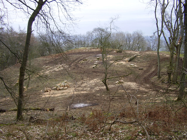
Well hidden: the slopes of Churchdown Hill are smothered with ancient woodland.

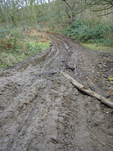
The first time I tried to discover the Mussel Well I didn't find it. Pitching into the faery-haunted woods below St Bartholomew's church, the magical church-on-a-tump which reminds me a little bit of Glastonbury Tor (only a bit flatter), I soon found myself hopelessly disorientated among the shady tangle of oak, ash and thorn. I squidged my way along endless stretches of boot sucking quagmire – abundant springs just under the surface ensure the paths remain perpetually muddy for most of the year – but realised I didn't have a clue where to look. I tried following my intuition, which led me towards a slight clearing in the trees on a steep slope (the whole hilltop is an Iron Age hillfort), but I was inadequately shod to make my way across an expanse of perilously sloping slop, studded with dog turds, to get to it, and so I reluctantly gave up. Not that I'm a cissy about falling on my arse in the mud, but I prefer not to do it with an expensive camera dangling round my neck. My frustration was increased when I got home and referred back to the maps because I realised that I'd been going the right way and must only have been a matter of yards away from finding it.

So I went back another day with a renewed resolve and a robust pair of boots. This time I got through the mud obstacles with ease, sending iridescent flies spinning from chunks of canine crap in the sunlight, but still no well. I trekked down the path one way, then trekked back up it the other way, all to no avail, and thought I was going to have to give up again. And then a distinctly smug voice in my head said "it's not so hard to find, you know." Meaning that oh yes it is hard to find, but my inner senses could lead me to it if only I'd let them. A moment later I noticed a narrow, informal path running up the rampart slope between the trees, and up it I went. Still no sign of a well, but half way up the earthworks my eye was drawn to a very imposing tree. An old hollow ash with whirls of ivy draped over it and a tall, triangular opening at the base.


Now, holey trees like this are a magnetic draw to my pagan soul, so I went over to get a closer look at it. There was something so powerful about its aura though that I was afraid to go too close; this was a tree Not-To-Be-Messed-With. I've rarely seen ash trees as big and old as this, and it appeared to be part of a row of mature ashes standing in a line; even within the wood with other trees all around, they stood out as venerable sentinels. And when I looked at the next one along, another tangle of ancient boughs, I saw that snuggled under its roots was a stone trough. Aha!


The Mussel Well – and I assume this is the Mussel Well, although there's no sign to say so – is an unprepossessing rectangular trough of indeterminate age, repaired or rebuilt multiple times by the look of it, obscured by dirt and moss and encroached by brambles. The water emerges from a metal pipe in a concrete block embedded into the hillside and falls into the trough, which is only a few inches deep and partially filled with well-rotted crud. The water then flows out through a second pipe at the front end. But maybe flows isn't the right word, because it's really somewhere between a trickle and a drip. So slight, in fact, that there's no drainage as such. The water drips into what appears to be a fairly primitive soakaway and barely even wets the ground. Intriguingly though, the ground below the well has a gulley cut through it as if there were formerly a stream running down the slope, although it's now dry and filled with brambles. There are also a few bits of stone lying about, half buried, which may have been part of it at some point.


Because of the slowness of the flow, the water in the trough is stagnant. I have a little self-anointing ritual I normally do when I encounter a well or spring, but the deep green depths of this pool revealed unappetising corpses of flies and worms and a host of unsavoury insect larva thingies wiggling about in it under a filmy sheen of gluck on the surface, and I really didn't feel inclined to dip my fingers in it. So I compromised by dipping my fingers in the drip of water coming out of the pipe, which was of course just as dirty and disgusting as the trough, but didn't look as horrible.

I'm not painting a very romantic view of this site am I? I have to say though, despite the state of the physical attributes, this felt like a spot with a bit of sacred whoomph behind it. Much of this was coming from the great gnarled and twisted ivy-mantled ash tree which stands guard beside it, a tree with a very active faery presence which takes its guardianship role very seriously, thank you very much. It's no good telling the tree spirit that the well is dirty and polluted; it presides over an older and deeper presence which goes beyond physical conditions.

The guardian of the well

Aside from the ambiance of the place, what can I tell you about the well? Available information is negligible. Most guides to Churchdown Hill make mention of the Mussel Well (frequently misspelt "Mussell") but none seem to offer any enlightenment. The local authority tourist information singles it out as one of the significant historical sites on the hill, and then says simply: "its history is obscure." Right, OK then. There doesn't seem to be any clue as to why it's called the Mussel Well, which I assume doesn't have anything to do with molluscs because the name appears to have evolved from an earlier form spelled "Muzzel". And there aren't any molluscs around here anyway, except fossilised ones. Perhaps the answer lies in an obscure land deed or reference library somewhere.

The Woodland Trust, who own and manage the woods, don't have a lot of historical information either, but they do mention in their leaflet that the Mussel Well provides a water supply to nearby Green Farm via a hidden pipe. If that's the case, then it explains why the current flow of the well is so depleted, and why it has the appearance of having been more gushing in the past. It's hard to guess at the age of the trough, as it looks to have been patched up several times; it has some white ceramic-lined bricks which look to be about a century old, and the lower stonework appears older. The alternative name, the Roman Well, implies that the site, if not the trough, dates back to Roman times – but such names can be misleading. There's no doubt that Churchdown Hill was a site of interest and activity for the Romans, and there's a set of steps credited to them on a nearby slope. But the bank in which the well is set is part of the Iron Age earthwork, long predating the Roman occupation. The well must surely have been known by the Dobunni people who lived here in pre-Christian times, although whether it was simply a water supply or had a religious significance I don't know (though I know what my intuition tells me).


One of the only references I've found in any of my books is in Stephen Yeates' A Dreaming for the Witches (which, interestingly enough, has an aerial photo of Churchdown Hill on the cover). He cites an earlier history of Churchdown by W.T. Swift, published 1905, which reports sightings of a faery funeral procession coming through the entrance of the Iron Age ramparts and disappearing into the hillside at an ash tree by the Mussel Well. There are of course many folk traditions about faeries seen or encountered at a well in the woods: the Mabinogion, the legend of the Faery Melusine, the folk song Tam Lin, and many medieval literary sources. As bonkers as these things may seem to modern readers, I have to say that having felt the aura of awe around that opening in the ash tree, not to mention the intensely solicitous green guardian of the ash tree beside the well, the idea of this place being a long established portal into faery doesn't seem very surprising to me!

Thursday, March 15, 2012

Crickley Level, Crippets Tump


Larches are most fitting small red hills
That rise like swollen antheaps likeably
And modest before big things like near Malvern
Or Cotswold's farther early Italian 
Blue arrangement; unassuming as the 
Cowslips, celandines, buglewort and daisies 
That trinket out the green swerves like a child's game 
O never so careless or lavish as here, 
I thought, You beauty! I must rise soon one dawn time 
And ride to see the first beam strike on you 
Of gold or ruddy recognisance over 
Crickley level or Bredon sloping down. 
I must play tunes like Burns, or sing like David, 
A saying out of what the hill leaves unexprest 
The tale or song that lives in it, and is sole, 
A round red thing, green upright things of flame 
It is May, and the conceited cuckoo toots and whoos his name. 
(Ivor Gurney)


Crickley Hill is one of the most dramatic sites on the Cotswold ridge, overlooking the Severn Valley with a view which takes in the tower of Gloucester cathedral and the Malvern Hills beyond. On clear days you can gaze as far as the Black Mountains of Wales. Much of the Cotswold ridge undulates gracefully and is flat and level on top, hosting wide smooth fields of corn and ribbons of ancient coppiced woods, and Crickley Hill blends so seamlessly with its neighbour Shurdington Hill that you can walk from one to the other without noticing. On its other side however it has a steep, spectacular scarp plunging down into a green valley, and this is what made it so attractive as a site of human settlement, going back into the stone age. 


Along the spine of the hill on its western edge is a long grove of very old beech trees, many over 200 years old and exquisitely gnarled, their ancient roots rummaging the mossy lines of tumbled drystone walls and forming natural hollows and stoups which collect rainwater in deep canopied shade. The thick carpet of leafmould creates silence underfoot but all the noise is overhead in the rushing of the wind through the boughs. The beeches grow in dense dark clusters but some of the open parts of the hilltop are also lined with beech trees along some of the steepest slopes, and these were probably planted in previous centuries to help reduce erosion of the crumbly limestone edge. 

Crickley's most obvious feature is its iron age fort whose ramparts dominate the hillscape, but there are more subtle traces of a fortified village and ritual site from much earlier times. On the western edge, overlooking the beautiful valley, a small neolithic shrine was built which originally took the form of a paved circle. It later acquired a small building, which was approached by a fenced path and was found to have had fires lit outside it. After some 400 years it was replaced by a cairn and a small stone circle, paved with cobblestones on the inside with a slab in the centre, which bore traces of burning. The pattern of trampling around the circle shows that it was circumambulated in a clockwise direction. Finally, in the bronze age, the whole shrine was covered with a long low mound resembling a long barrow. The stone circle is still there, but you might be disappointed if you go looking for it. Having been found by archaeologists investigating the long mound, it was decided to re-bury it for its own good. Although the surface remains may be limited, the deep sanctity of this place is not difficult to appreciate. 


The village of Shurdington and the dark mound of Churchdown Hill, seen from Crickley Hill

You don't have to go far to find an actual long barrow either, or a tump as they are called in Gloucestershire. The sweeping slope across the hilltop to Shurdington Hill is crowned by a large neolithic barrow, 189 feet long and 20 feet high, oriented east-west, and now topped by a cluster of coniferous trees. While the trees may have invaded the ancient remains below the ground, they have at least protected it from ploughing, as evidenced by the fate of a round barrow a short distance away in the same field. The round barrow is almost entirely ploughed out and its site can now be located only with a good map and a keen inner sense. 

The Cotswold area is well known for its proliferation of long barrows and they represent some of the oldest architectural structures in Europe. The Crippets long barrow is around 4000 years old. At the eastern end is a semi-circular indentation which could very easily be mistaken for a horned false-entrance of the type seen on other local barrows such as Belas Knap. Unfortunately it's not; it's the scar left behind by 18th century treasure-seekers, who ripped away a large chunk of the barrow some time around the 1770s. Needless to say the results of this clumsy pillaging were not formally recorded, the only contemporary source reporting that a cromlech was found inside containing a single skeleton (subsequently lost) and a metal helmet which was so rusted that it dissolved to dust on contact with the air. Quite how you manage to lose a human skeleton is not entirely clear; perhaps somebody in one of the old farmhouses in the area will get a surprise one day while clearing out the loft. 


The rusted metal helmet does raise an intriguing question though. The people who built the barrow, in the late stone age, were not in possession of iron or the skills to work it. The metal helmet couldn't have belonged to them. So how did it end up interred within their burial chamber? 

The most likely explanation is that it belonged to a later Anglo-Saxon burial. As strange as it may sound, the Anglo-Saxons often re-used neolithic burial mounds for their own high profile interrments. This seems to have been done for the most respectful of reasons, as an attempt to continue a tradition or to connect with the ancestors – a desire to lay their own illustrious dead in an established sacred place alongside those who had occupied and cherished the same land centuries earlier. 

To the eyes of vision, the Crippets barrow might show itself as a centre of inner activity, for the Cotswold faeries are considered to inhabit all hollow hills, natural or man-made. You might, in vision, stand on the crest of Crickley's undulation under a horned moon and look towards Crippets on the horizon, see the pulse of saturated colour in the faery light of the barrow, orange and purple and carmine streaming into the aura of the night sky. If you're very lucky, you might catch the tumbling shimmers of their music on a passing breeze. 


This article first appeared on the Miles Cross blog.

References: Timothy Darvill, Long Barrows of the Cotswolds (Tempus Publishing, 2004).
Map Ref for Crickley Hill: SO928161 / Landranger OS map 163 
Map Ref for Crippets Long Barrow: SO934173 / Landranger OS map 163

Sunday, February 26, 2012

Midsummer murders

BEFORE: Bluebells on Midsummer Hill

Last April I took some photographs of the magnificent bluebell woods on Midsummer Hill, an iron age hillfort in the southern stretch of the Malvern Hills. These magnificent old woods of mixed native trees are one of the best sites I know for the uniquely English phenomenon of "bluebell carpets", as the mature and unspoilt woods provide a perfect habitat for the flowers to thrive. The magical sensation of these glowing undulations of blue has to be experienced to be believed – to be surrounded by an ocean of azure (and occasionally white) wild blossoms with the spring sun rippling through the new leaves was one of the most moving things I experienced in 2011. Little did I realise at the time that it would be the last time the bluebells would flower in the Midsummer woods.

Soil Disturbance and Brash Fires on Midsummer Hill Hillfort
AFTER: Is this really how you "conserve" a Scheduled Ancient Monument? Tyre-track damage all over the 2,400-year-old ramparts. (Photo by Creda's Hill)

Why anybody would condone such an act of vandalism is difficult to fathom, but there are of course reasons why this devastation is considered appropriate, even "necessary". Midsummer Hill is in the care of the Malvern Hills Conservators, a publicly funded body whose job is to conserve the Malvern Hills (yes, there's a clue in the name). Inevitably there are conflicts of interest in their work. Midsummer Hill is a scheduled ancient monument, the entire top of the hill being occupied by a large iron age hillfort, and it's important that the archaeological integrity of the site be maintained. Parts of the ancient ramparts are wooded to varying degrees, and there are concerns that tree roots may be damaging or disturbing the ground beneath the earthworks. The site is also a designated SSSI (Site of Special Scientific Interest) and so consideration has to be given to the rare birds, butterflies and wildflowers which thrive in the very special Malvern habitat. The Conservators have explained that the work to clear "scrub" from the site has been approved in consultation with various respected bodies such as the National Trust and English Heritage and is considered necessary.

Another reason they want to do this work is to improve visibility of the hillfort and increase the amount of open grassland for the public to enjoy. And the clearance is supposedly limited to scrub. "The most valuable trees for wildlife including beech, hawthorns and field maples are being left."

Well something has gone horribly wrong. Mature trees, including the distinctive twisty "faery" hawthorns and large ash trees of more than three feet diameter have been felled. The bluebell woods have been slashed and burned. The hillside is pocked with scorched patches. The ancient ramparts, in the interests of being protected from "tree-root damage", have been rutted and churned up with tyre-tracks from the heavy equipment used by the contractors.

April 2011

Tractor Ruts on Midsummer Hill Hillfort

February 2012
(photo by Creda's Hill)

It's hard to know exactly what is happening here. The felling work has been contracted to a commercial firm, who are making a godawful mess. Whether they are doing so within the terms of their contract or whether they are taking shameful liberties is not clear. Either way, the responsibility lies with the Malvern Hills Conservators to ensure that the work is being carried out properly and sensitively.

There also appears to be a discrepancy between what was authorised and what is actually happening. The damage already covers an area substantially beyond the planned limits.

Map of Midsummer Hillfort. The areas outlined in blue show the areas of proposed "scrub clearance". The area marked in orange shows the current extent of the damage. (Map from the Save the Malvern Hills from the 'Conservators' campaign page.)

Anyone who has visited Midsummer Hill will be in no doubt that it's a very special place. The size of the hillfort is enormous, and it's a split-level job, so large you can't really see it all in one go (with or without the trees). The upper part sits on the crest of the Malvern ridge where its rocky backbone pokes through the thin, grassless soil, and the wind blasts unstoppably. If you can manage to stand up in it you can get a spectacular panoramic view across the fields of Worcestershire and the green undulations of Herefordshire, as well as along the rippling spine of the Malverns. The lower section of the hillfort, a short way down the wooded slopes, is a beautiful greensward burgeoning with tiny flowers. It features a curious and unidentified "pillow mound", which looks like a long barrow but probably isn't. The fort in its heyday (about 390 BC) supported a very large community, who lived in wattle and daub houses and had a very self-contained village within the revetted double-ramparts. A spring which still flows through the bluebell woods provided them with a plentiful supply of water.


The lower section of the hillfort. To the right of the walking couple is the mysterious pillow mound.

Today the fort is an important nature reserve where wildflowers, birds and rare butterflies make every walk here an absolute delight at any time of the year.

Native British bluebells, Hyacinthoides non-scripta, growing within the ramparts of Midsummer Hill.

So much for the archaeological and wildlife treasures. Midsummer Hill is also a place where the veil is thin and resonant with ancient spirits. No pagan soul could fail to be enthralled by the dance of Oak and Ash and Thorn through the tappetting woods, and those who are attuned to Faery will find the gates here are wide open.


No doubt within a season or two the damaged land will be green once again and wildflowers (albeit not bluebells) will spring up on the ramparts, providing food plants for butterflies and joy for passing humans. But none of that excuses the horrible devastation of such a precious and dearly loved woodland or the insensitive and clumsy way the work has been carried out. For those of us who consider Midsummer Hill to be a special and sacred place, the loss of the magical woods is an irreparable scar.

Please help local people and other friends of the Malverns to fight back against these ravages, even if only by helping to share and support their Facebook page. It's not too late to stop other parts of the hill from being desecrated.

My thanks to Creda's Hill for making their photographs of the devastation available on a Creative Commons licence.

Saturday, December 3, 2011

Crickley Hill

Crickley Hill

You hills of home, woodlands, white roads and inns
That star and line our darling land, still keep
Memory of us; for when the first day begins
We think of you and dream in the first sleep
Of you and yours –
Trees, bare rock, flowers
Daring the blast on Crickley's distant steep.

(Ivor Gurney, "Crickley Hill")